Friday, August 29, 2008

Atwater Stairs - Milwaukee, WI


I was in Wisconsin for a long weekend, and managed to spend most of it drinking and eating. I had never been to Wisconsin, so it was fun getting to explore a part of the country I usually associate with cheese and the Packers. After visiting, I still associate it with cheese and the Packers. But we did manage to find the best bloody mary I've ever had, which was done in true Wisconsin style; with smoked meat and mozzarella string cheese garnish. Yes, you read that right. It was amazing, definitely one of the highlights of my foray into America's dairy land. Wicked Hop is the place to visit if drinking spiked tomato juice with meat and cheese is on your agenda.

As is usually the case, I didn't work out much while visiting. For me, one of the hardest parts about traveling is staying motivated to work out. Usually travelings means meals on the road and random sleeping situations, so keeping to a routine is usually last on my mind. Typically I stick to just running around whatever area I'm staying in, but in some cases I manage to come across a feature that makes for a great workout. One of these recently was the Atwater Stairs, on the shore of Lake Michigan in Milwaukee, Wisconsin.

The stairs are composed of about 8 sections of 15 or so stairs, running from the beach up to a park that overlooks the water. In addition to the stairs, there is a paved path that also runs down to the beach. I ended up doing a quick run in the neighborhood followed by some stairs laps, which worked me over pretty well. The scenery was great, and the neighborhood provided a nice setting for a run. My time is Milwaukee was spent mostly eating and drinking, but the stairs made for a great diversion from my travel routine of being a lazy bastard.

Atwater Park is about 4 miles north from downtown Milwaukee, on the western shore of Lake Michigan. Click on the map below for directions.


View Larger Map

Friday, August 15, 2008

Paul Intemann Memorial Trail - Manitou Springs, CO


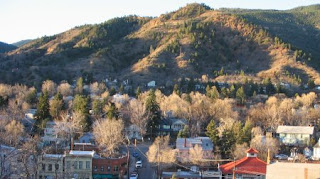
Running along the southern rim of the valley in which Manitou Springs resides is the Paul Intemann Memorial trail, a 5+ mile trail built by a completely volunteer force that winds from the western edge of town into the eastern edges of Colorado Springs. The trail is named after city planner Paul Intemann who was killed in a car accident in 1986. Over the years the trail has grown and been extended, and exists as a great memorial to Paul's work in making Manitou Springs a wonderful place to call home.

The trail winds the entire extent of Manitou Springs, making it a great first arrival destination for anyone looking to get a bird's eye view of the town. From the trail, both the Incline and Red Mountain are easily accessible. In general, the trail is great for running, with only a view steep parts. For the most part the trail is dirt, with some paved sections which function more as connection points to the dirt sections. The most easily accessible trail head is the Iron Springs Trailhead, which can be reached by taking Manitou Ave west to Ruxton Ave. Follow that up the canyon until the Iron Springs gazebo.

Thursday, August 14, 2008

Red Mountain - Manitou Springs, CO


From downtown Manitou, one of the dominant mountains that overlooks town is Red Mountain, so named for the red sands and granite that give the mountain its unique tinge. In town, the mountain is known for two things; the traditional launching site for the town's 4th of July fireworks, and Emma Crawford's coffin, which managed to wrench its way out of the red sands in which it was buried and travel down the mountain in a mudslide until it reached downtown. This little event inspired Manitou's famous Emma Crawford Race.

I had hiked Red Mountain when I was younger but was never too curious about it until my brother showed me a new trail that winds to the top of it. The Red Mountain Trail is a spur of the Intemann Trail, and winds about 2 miles to the summit of the mountain, where a large concrete platform awaits. Running, it took about 16 minutes from the beginning of the trail to the summit. For the most part the trail is fairly steep, with a lot of loose gravel at the beginning. But as you climb, the trail becomes more firm and levels out a bit.

By itself, the trail is a pretty short workout. But worked in with a longer run along the Intemann trail, it makes for a great out and back leg burner. My plan the next time I head back to town is to combine Red Mountain with the Incline for a long climbing day.

From downtown Manitou Springs, take Manitou Avenue west and turn left at Ruxton. Park near the Iron Spring gazebo and head up the dirt road (Spring Street) and take your first right. The trailhead starts at the chained off road, and the spur for Red Mountain is about a mile into the trail (heading east).


Wednesday, August 13, 2008

Coffee is my sports drink of choice

I was not much of a coffee drinker when I was in college. But after moving to Portland, OR I quickly found that coffee was not only the best way to start a morning, but essential to surviving the dreary winter and spring that is a Portland hallmark. My favorite coffee shop in Portland is Stumptown, which roasts its own beans and is slowly managing to work its way into a market dominated by Starbucks. I have found a few nice places in Boulder, among them Amante and The Cup, but nothing has lived up to the sweet elixir that is a double shot Americano from Stumptown.

My ridiculous addiction to coffee has led to trying to pay attention what people write about the effects of coffee. I tend to drink it before I ride or run in the mornings so I'm always curious to see how coffee can effect performance. This article from the New York Times talks about the various health effects of coffee. One of the more interesting bits of information talks about how coffee can improve both aerobic and anaerobic performance. Just another reason to pour another cup.

Tuesday, August 12, 2008

Manitou Springs, CO


The more I come back to Manitou, the more I grow to love it. I grew up here, so I've been able to see the changes over the years, and there have been a lot. At its core, Manitou is tourist hamlet of 5000 full-time residents with an array of various tourist attractions, like the Cog Railroad and the Cave of the Winds that are derived from the hills and mountains that surround the town. Growing up, the main street was filled with kitschy T-shirt shops and souvenir stores. Some of them still exist, but the town has undergone a bit of a renaissance as of late, with a variety of great new stores moving in, and the sidewalks and streets undergoing a renovation. Old, dilapidated buildings have been renovated and the town overall is much improved.

Manitou is known more as an artists enclave than as an outdoor destination, but there are a variety of great work out venues easily accessible from town. Foremost among them, at least in my eyes, is the Incline, by far one of the most strenuous things I have ever done. Adjacent to the Incline is Barr Trail, which winds to the top of Pikes Peak and is home to both the Pikes Peak Ascent and the Pikes Peak Marathon. Winding along the southern hills through town is the Paul Intemann Memorial Trail, a great multipurpose trail that is mostly dirt and extends from the west end of town all the way into Colorado Springs. There are numerous offshoots from the trail which lead on to other great runs and hikes.

Farther to the east of town sits the Garden of the Gods and Red Rock Canyon, both part of the same geological formation of vertical standing sandstone, and both home to great running
and hiking trails. Garden of the Gods is a great place to ride as well;
every road through the park has an accompanying bike lane.

I'm excited to see how the town evolves in the future. I would love to see more high end shops moving in, along with a bigger variety of restaurants. It would also be great if the town could develop a broader ranger of mountain biking access and more running trails. But overall, the town is definitely up and coming. The more I experience other places, the more I love coming home.

Saturday, August 9, 2008

Hoosier Pass - Breckenridge, CO


To the south of Breckenridge lies Co-9, a two lane road that winds its way to the top of the valley that frames the southern view from town. The summit of the pass sits at 11,541 ft., and provides a great viewpoint of some of the peaks and valleys that surround the summit county area.

As a ride, Hoosier Pass is somewhat short, only 10.3 miles from downtown Breck to the summit of the pass, but in that 10 miles you climb almost 2,200 feet (Breckenridge sits at 9,603ft), which makes the Pass a great workout that will not take all day. From downtown Breck, head south (the ski mountain will be on your right), on Main Street which will eventually turn into CO-9. You will know you are headed in the right direction when you pass the Breckenridge Brewery on your left.


Sidenote: The Breck Brewery is one of my favorite places in town. It has the typical brewery food ( their black bean burger is one of the best I have ever had), but what really sets it apart is the beer. They produce some of the most distinctive beers that I have come across. The Vanilla Porter is my favorite. The brewery is definitely worth checking out while in town.

Following Co-9 out of town, you will pass the town/neighborhood of Blue River on your left. The road remains pretty gradual until it starts hitting the switchbacks. From what I can remember, the road is in decent condition, but there is not much of a shoulder. However, most of the drivers seem cognizant of bikers on the road. We did have an encounter with a driver who honked and screamed at us, apparently angry that he had to move a foot or two to the left of his lane. Or maybe he didn't like all of the spandex.


View Larger Map

Friday, August 8, 2008

Aspen, CO


We just got back from visiting a friend in Aspen, the epitome of Colorado ski towns. It is literally everything I picture when I think of a ski town; a great mountain that is within walking distance of almost any place in town, incredible snow, great apres-ski opportunities, and of course, insanely expensive pricing on everything. My usual gauge for determining the expense level of a town is the cost of a double-shot Americano. In Portland, or even Boulder, the average price for a 160z Americano runs about $2.20. In Aspen, I usually pay closer to $3.00. So, I generally assume everything in town will run about 36% more than I'm used to paying.

Like other ski towns, many of the people that live there are divided into the locals, the migrant worker force and the seasonal residents. The migrant worker force consists mostly of incredibly wealthy European kids that have come to Aspen to run a lift line and drink as much as they can. The seasonal residents are people like Kevin Costner and Goldie Hawn. On our visit we walked past Lance Armstrong, who was in town training for the Leadville 100. His training group included the friend we were visiting, leading to a few somewhat surreal "how was Lance feeling today" type of conversations. This is why Aspen is my paradigm of a proper ski town.

Apart from the glamour aspect, the town is a great location for some of the most scenic riding and running that I've done, and Aspen Mountain has a couple of great trails that are good for hiking or running. Although not as expansive as Boulder, the riding is incredibly scenic and just as easily accessible. The Hub is a great shop in town that can provide some knowledge about some great local rides.

Sunday, August 3, 2008

Breckenridge, CO


Growing up in Colorado, I have had the opportunity to check out a lot of the cities and towns in the State. One of my favorites is Breckenridge, in Summit County Colorado. Summit County is known for the sheer number of ski resorts it hosts, among them Vail and Copper Mountain. Breckenridge has the ski resort vibe going on, but it is also a great town with a lot of great things to do.

Like Aspen and Telluride, Breckenridge began as a mining town. When the mines stopped producing, the range of peaks to the south became the economic anchor of the town. Due to the large number of mines, the valley floor that Breckenridge sits in used to be covered in huge piles of stone, the result of dredging in the mines. The town has spent years reclaiming the valley floor, and from what I remember growing up, the progress has been amazing.

The Blue River winds through town, and has been the focal point for a lot of the reclamation projects the town has undergone. Along the river winds a multi-use path that runs 16 miles up to Copper Mountain resort, and from there connects to another paved trail that runs to Vail. Great for running and biking. Breck is also surrounded by some great rides, among them Hoosier Pass, Vail Pass, and Loveland Pass, all of which climb to at least 10,000+ feet. And of course the town is host to some great skiing and snowboarding during the winter.

Friday, August 1, 2008

Mt. Evans Hillclimb - Idaho Springs, CO


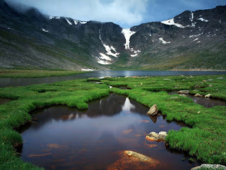
Building a road to the top of a 14,000 plus foot mountain is, to me, a quintessential American endeavor. Where else would someone expend hundreds of thousands of dollars and hundreds of hours of labor to build a road up a mountain, so that we can drive, instead of hike, to the top of a mountain?

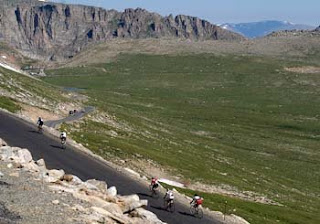
The Bob Cook Memorial Mt. Evans Hillclimb takes advantage of the road that winds to the top of Mt. Evans. Beginning in Idaho Springs, CO, the road, classified as a scenic byway, winds 27.5 miles to the top, gaining 6580 ft. in elevation from the beginning of the race to the finish line. The race is divided into categories, and features a group start that sticks together for about 6 miles until the elevation gain starts to separate everyone. I've found that the key to the race is to stick with the pack for as long as possible, and then hook into a pace line for the remainder. The beginning of the race, all the way up to Echo Lake is fairly gradual. Once you get above treeline the wind kicks in, making a pace line essential. The steepest part of the course is about the last three miles, where a series of switchbacks kick in.

Mt. Evans is one of my favorite races, although I am conflicted about it. On one hand we are racing up a road that has cut a huge scar through some of the best scenery in Colorado. The race fees don't go toward any sort of forest management or conservation programs. On the other, the road is there, so why not take advantage of it?